In the past, when our clients manifest having mobility issues, they are usually able to walk the required distances from the bus to the locations with the help of their family or companion.
FAQ
We typically publish our tours 1-1.5 years in advance which makes is convenient for our guest to book well in advance to avoid disappointment. If you can’t find the information you are looking for on our website, please contact us.
The animals have a big enclosure to move freely, and they decide if they approach to the buses and visitors or not. We do not force interactions, taking care of the animal and sticking to the rules of the wildlife preserve. Usually, the animals are close to the feeding stations or the fence, and we can photograph and observe up close, but we respect when they want their space.
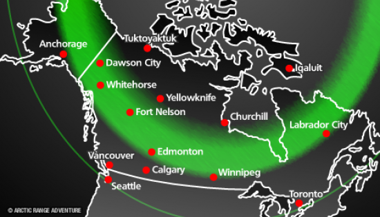
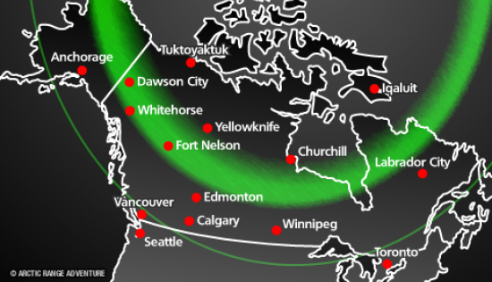
Three Day - Aurora Weather Forecast
Whitehorse (Canada)


Yukon Climate
| Month | Jan | Feb | Mar | Apr | May | Jun | Jul | Aug | Sep | Oct | Nov | Dec | Year |
|---|---|---|---|---|---|---|---|---|---|---|---|---|---|
| Record high °C (°F) | 10.0 (50) |
11.7 (53.1) |
16.8 (62.2) |
21.8 (71.2) |
34.1 (93.4) |
34.4 (93.9) |
33.2 (91.8) |
31.6 (88.9) |
26.7 (80.1) |
19.3 (66.7) |
13.3 (55.9) |
10.6 (51.1) |
34.4 (93.9) |
| Average high °C (°F) | −11.0 (12.2) |
−7.7 (18.1) |
−0.7 (30.7) |
6.6 (43.9) |
13.5 (56.3) |
19.1 (66.4) |
20.6 (69.1) |
18.5 (65.3) |
12.1 (53.8) |
4.2 (39.6) |
−6.0 (21.2) |
−8.5 (16.7) |
5.1 (41.2) |
| Daily mean °C (°F) | −15.2 (4.6) |
−12.7 (9.1) |
−6.3 (20.7) |
1.0 (33.8) |
7.3 (45.1) |
12.3 (54.1) |
14.3 (57.7) |
12.6 (54.7) |
7.2 (45) |
0.5 (32.9) |
−9.4 (15.1) |
−12.5 (9.5) |
−0.1 (31.8) |
| Average low °C (°F) | −19.2 (−2.6) |
−17.6 (0.3) |
−11.9 (10.6) |
−4.6 (23.7) |
1.0 (33.8) |
5.6 (42.1) |
8.0 (46.4) |
6.7 (44.1) |
2.1 (35.8) |
−3.2 (26.2) |
−12.9 (8.8) |
−16.5 (2.3) |
−5.2 (22.6) |
| Record low °C (°F) | −56.1 (−69) |
−51.1 (−60) |
−42.2 (−44) |
−30.6 (−23.1) |
−12.9 (8.8) |
−6.1 (21) |
−2.2 (28) |
−8.3 (17.1) |
−19.4 (−2.9) |
−31.1 (−24) |
−47.2 (−53) |
−48.3 (−54.9) |
−56.1 (−69) |
| Average mm (inches) | 17.8 (0.701) |
11.8 (0.465) |
10.3 (0.406) |
7.0 (0.276) |
16.3 (0.642) |
32.4 (1.276) |
38.1 (1.5) |
35.8 (1.409) |
33.3 (1.311) |
23.2 (0.913) |
20.1 (0.791) |
16.3 (0.642) |
262.3 (10.327) |
| Average rainfall mm (inches) | 0.3 (0.012) |
0.0 (0) |
0.0 (0) |
1.2 (0.047) |
14.3 (0.563) |
32.4 (1.276) |
38.1 (1.5) |
35.5 (1.398) |
29.0 (1.142) |
8.8 (0.346) |
1.0 (0.039) |
0.4 (0.016) |
160.9 (6.335) |
| Average snowfall cm (inches) | 25.4 (10) |
18.3 (7.2) |
14.8 (5.83) |
7.2 (2.83) |
2.0 (0.79) |
0.0 (0) |
0.0 (0) |
0.3 (0.12) |
4.7 (1.85) |
18.6 (7.32) |
27.0 (10.63) |
23.5 (9.25) |
141.8 (55.83) |
| Average precipitation days (≥ 0.2 mm) | 11.2 | 8.3 | 6.4 | 4.4 | 8.0 | 10.9 | 13.5 | 12.5 | 11.9 | 11.5 | 11.5 | 11.2 | 121.2 |
| Average rainy days (≥ 0.2 mm) | 0.2 | 0.1 | 0.1 | 1.1 | 7.5 | 10.9 | 13.5 | 12.4 | 11.0 | 5.1 | 0.8 | 0.3 | 62.9 |
| Average snowy days (≥ 0.2 cm) | 11.9 | 9.1 | 7.0 | 3.8 | 1.2 | 0.0 | 0.0 | 0.3 | 1.5 | 7.9 | 12.4 | 12.2 | 67.4 |
| Average relative humidity (%) | 72.2 | 64.5 | 51.8 | 42.1 | 38.2 | 39.9 | 46.0 | 47.9 | 54.5 | 64.2 | 75.2 | 74.7 | 55.9 |
| Mean monthly sunshine hours | 43.8 | 105.5 | 163.2 | 238.5 | 251.1 | 266.7 | 247.6 | 226.5 | 132.7 | 84.9 | 39.8 | 26.8 | 1,827.1 |
| Percent possible sunshine | 21.4 | 41.6 | 44.8 | 54.4 | 46.8 | 46.9 | 43.8 | 46.4 | 34.1 | 27.0 | 17.8 | 14.9 | 36.7 |